The 1215–1240 MHz range sits in the lower L-band and plays a vital role in aviation, defense, and satellite navigation. It’s a protected portion of spectrum, heavily regulated and used for long-range radar and satellite navigation systems rather than commercial or unlicensed applications.
Overview
This band supports aeronautical radionavigation, radar surveillance, and satellite navigation. It’s also part of the broader 1215–1300 MHz segment used by the Global Navigation Satellite Systems (GNSS) such as GPS, Galileo, and GLONASS. Because it’s used by safety-of-life and defense systems, the band is strictly managed and coordination is essential to prevent interference.
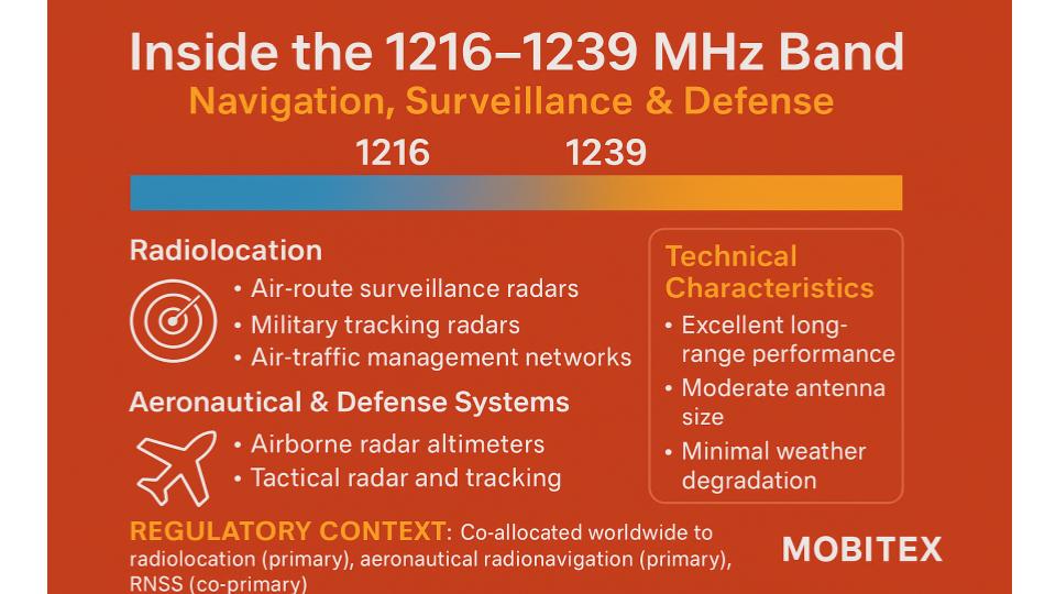
Key Services and Allocations
Radiolocation (Radar)
Most of this band is allocated to radar systems used for air-route surveillance, border protection, and early-warning detection. The frequency range allows radar to detect targets over long distances because of low atmospheric attenuation and minimal background noise.
Radionavigation-Satellite Service (RNSS)
This range includes satellite navigation downlinks. GPS and other GNSS systems use frequencies near 1227 MHz, known as the L2 band. These signals assist in precision navigation and timing for civil, aviation, and military users.
Earth Exploration and Space Research
Portions of the band support active sensors used for spaceborne radar imaging and Earth observation. These operate under strict limits so they don’t interfere with radar and navigation systems already in the band.
Why This Band Is Used
The 1.2 GHz range provides an ideal mix of long-distance propagation, high-power radar efficiency, and manageable antenna size. It allows radars to detect small or distant objects even in poor weather. For satellites, it penetrates clouds and precipitation better than higher microwave bands, making it reliable for navigation and mapping.
Regulatory Context
The International Telecommunication Union (ITU) allocates this band primarily to radiolocation and radionavigation services. Satellite navigation systems are allowed but must not interfere with those radar operations. National regulators such as the FCC, ISED, and Ofcom follow these allocations, designating the band mainly for aviation and defense radar with satellite navigation as a co-primary service under strict protection rules.
Practical Uses
- Air-Route Surveillance Radars: Ground-based systems track aircraft across wide regions, supporting air-traffic management.
- Defense and Border Security: Military and surveillance radars operate here due to its long range and reliability.
- GNSS L2 Signals: GPS and similar satellite constellations transmit navigation signals around 1227 MHz for dual-frequency receivers.
- Spaceborne Sensors: Some radar imaging satellites use nearby frequencies for Earth observation and scientific missions.
Considerations for Spectrum Managers and Designers
Because of its high-priority users, any new system in this band must avoid interfering with radar or satellite navigation. Equipment developers should use tight filtering and guard bands when operating near 1215–1240 MHz. Sharing possibilities are limited, and coordination is mandatory for any experimental or regional use.
Summary
The 1215–1240 MHz band underpins critical infrastructure worldwide. It supports air-traffic radar, defense surveillance, and global navigation satellites – making it one of the most valuable parts of the spectrum. For planners and engineers, it represents a protected domain where safety-of-life and navigation services take precedence over all other uses.