The 1640 MHz frequency sits in the L-Band (1–2 GHz) of the radio spectrum and plays a critical role in satellite navigation, telemetry, surveillance systems, and space-to-Earth communication. Although not as universally known as bands used for LTE or Wi-Fi, 1640 MHz is integral to aerospace and scientific applications and is often tightly regulated.
ITU Band: L-Band (ITU designation: Region 1, 2, and 3 compliant)
Wavelength: ~18.29 cm
This frequency range overlaps or borders bands used for satellite navigation, radionavigation-satellite services (RNSS), and space operation systems.
🌍 Regional Use Breakdown
🌐 Region
Use of 1640 MHz
Status
🌍 Region 1
Scientific and satellite services
Primary or shared
🌎 Region 2
RNSS, telemetry, spectrum surveillance
Shared, harmonized
🌏 Region 3
Satellite comms, telemetry (select areas)
Varies by country
🚀 Primary Applications
Application
Description
GNSS Downlink Channels
1640 MHz lies within ranges used by GNSS constellations like GLONASS
Telemetry (Aerospace)
Downlink for vehicle health monitoring and control systems
Spectrum Surveillance / SIGINT
Used by state and defense agencies for spectrum monitoring
Space Research & Operations
Receives data from spacecraft for scientific and observational missions
Custom Scientific Experiments
Earth-space radio signal propagation, ionospheric studies, etc.
📊 Technical Characteristics
Attribute
Value
Center Frequency
1640 MHz
Modulation Types
QPSK, BPSK, FSK, custom spread spectrum
Antenna Type
Helical, patch, directional arrays
Typical Bandwidth
Varies: 2–10 MHz allocations or narrowband
Link Type
Downlink or simplex (space-to-Earth)
Power Levels
Low-power (<10 W) to high-gain satellite class
🌐 Licensing & Governance
Organization
Role
ITU
Global coordination and regional harmonization
FCC (USA)
Regulates use within Region 2, especially for GNSS
ESA / CNES / ISRO
Space-based services using or bordering this band
Military & Intel Agencies
May reserve segments for non-public applications
🔐 Access & Restrictions
Heavily regulated due to international coordination
Not for license-free use
Subject to coordination between civil and military entities
Potential for harmful interference with GNSS and aircraft telemetry if misused
🔁 Spectrum Sharing & Interference Considerations
Shared spectrum with GLONASS signals (~1602–1616 MHz)
Adjacent to Earth Exploration Satellite Service (EESS) bands
Careful filtering and coordination required to prevent satellite downlink interference
Spectrum monitoring often enforced near this band for compliance
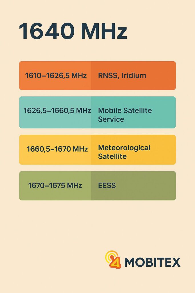
🛰️ Adjacent Bands Overview
Band
Frequency Range
Use
1610–1626.5 MHz
RNSS (e.g., GLONASS), Iridium uplinks
1626.5–1660.5 MHz
Mobile satellite service (MSS), telemetry, Inmarsat
1660.5–1670 MHz
Meteorological satellite, passive sensing
1670–1675 MHz
Earth Exploration Satellite Service
🧠 Summary Table
Feature
Value / Description
Center Frequency
1640 MHz
ITU Region
🌍 Region 1, 🌎 Region 2, 🌏 Region 3
Primary Use
GNSS-related downlink, aerospace telemetry
Access
Licensed only, tightly regulated
Notable Risks
GNSS interference, satellite downlink overlaps
Key Stakeholders
Space agencies, defense, spectrum authorities
🔭 Engineering Notes
Ideal for long-distance downlink from LEO/MEO spacecraft
Antenna designs require high directivity for low-EIRP signals
Filtering is critical due to proximity to sensitive navigation bands
Often used in custom SDR setups for space weather and science studies
Mobitex
📶 Mobitex helps engineers, regulators, and innovators navigate radio frequencies, decoding MHz to GHz with engineering-grade spectrum insights, tools, and clarity for better decisions.