The 1559–1610 MHz band is one of the most valuable and carefully protected portions of the radio spectrum. Known internationally as part of the L-Band, it powers the world’s Global Navigation Satellite Systems (GNSS) – including GPS, Galileo, GLONASS, and BeiDou. These signals allow billions of devices to calculate position, time, and velocity with remarkable precision.
In every region of the world, this band is allocated to the Radionavigation-Satellite Service (RNSS), with strict protections against interference from nearby mobile or broadcast systems.
📡 Frequency Range and Classification
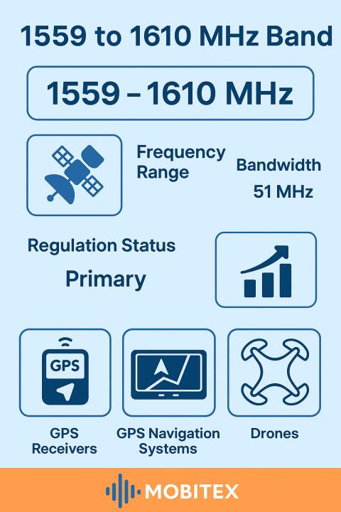
- Frequency Range: 1559 MHz – 1610 MHz
- Band Class: Radionavigation-Satellite Downlink (space-to-Earth)
- ITU Allocation: Primary allocation in Regions 1, 2, and 3
- Typical Wavelength: ≈ 0.19 m
- Band Family: L-Band
This is a downlink-only band. Satellites orbiting at medium Earth orbit (MEO) transmit navigation signals toward the Earth’s surface. Receivers – in phones, vehicles, drones, and timing systems — passively listen to these signals without transmitting back.
🛰️ Systems Operating in This Band
| System | Center Frequency (MHz) | Signal | Description |
|---|---|---|---|
| GPS L1 | 1575.42 | C/A, P(Y), M-Code | The most widely used navigation signal for civil and military use |
| Galileo E1 | 1575.42 | E1-B, E1-C | European GNSS providing high accuracy and authentication |
| GLONASS G1 | 1602 ± k×0.5625 | FDMA | Russian GNSS, uses frequency division to separate satellites |
| BeiDou B1 | 1561.098 / 1575.42 | B1-I, B1-C | Chinese GNSS with compatibility with GPS/Galileo |
| QZSS / NavIC | 1575.42 | L1 / L5 | Regional augmentation systems improving accuracy in Asia-Pacific |
These systems overlap in spectrum, yet coexist through signal design, timing codes, and international coordination.
⚙️ Technical Characteristics
- Propagation: Line-of-sight with strong penetration through light foliage and glass
- FSPL (1 km): ≈ 96 dB
- Fresnel Radius (1 km): ≈ 6.8 m
- Quarter-Wave Antenna: ≈ 0.047 m
- Half-Wave Antenna: ≈ 0.094 m
- Modulation: BPSK, QPSK, and advanced multiplexed codes
- Power at Receiver: Around −130 dBm (extremely weak; requires sensitive LNAs)
🧭 Applications
The 1559–1610 MHz band underpins a vast ecosystem of technologies:
- Positioning and navigation for smartphones, vehicles, aircraft, and ships
- Timing synchronization for telecommunications, financial networks, and power grids
- Surveying and mapping applications requiring centimeter-level precision
- Autonomous systems such as drones and robotics
- Augmentation systems like WAAS, EGNOS, and MSAS that improve accuracy
🧠 Regulatory and Protection Considerations
Because GNSS receivers depend on extremely weak signals, this band enjoys the highest level of international protection. Regulators enforce:
- Strict out-of-band emission limits for adjacent mobile systems (e.g., MSS 1525–1559 MHz)
- Prohibitions on active transmitters within the band
- Guard bands around 1559 MHz and 1610 MHz to isolate RNSS from other L-band services
Even small amounts of interference – from unfiltered transmitters or poorly shielded electronics – can degrade GNSS accuracy or cause total loss of signal.
⚙️ Market and Ecosystem
The GNSS industry represents trillions of dollars in economic value globally. Every smartphone, aircraft, delivery vehicle, and precision-agriculture system depends on these frequencies.
A healthy ecosystem of chipsets (u-blox, Broadcom, MediaTek, Qualcomm) and antennas (patch, helix, L1/L2/L5 multi-band) ensures widespread availability and continuous innovation.
⚠️ Known Issues and Challenges
Despite its importance, the 1559–1610 MHz band faces ongoing challenges:
- Adjacent-band interference from high-power mobile satellite transmissions near 1559 MHz
- Multipath effects in urban areas causing positional drift
- Ionospheric delay at low elevations
- Spoofing and jamming by malicious or accidental sources
- Shared spectrum complexity between overlapping GNSS systems
To counter these, modern receivers employ dual-frequency tracking, anti-jam filters, and signal authentication (e.g., Galileo OSNMA).
🛰️ Summary
The 1559–1610 MHz band is the core of the world’s navigation infrastructure – a silent symphony of satellites continuously broadcasting precise timing information that keeps our phones, planes, and entire economies synchronized. Its protection ensures global safety, security, and scientific advancement.