Frequency
1633 MHz
Range
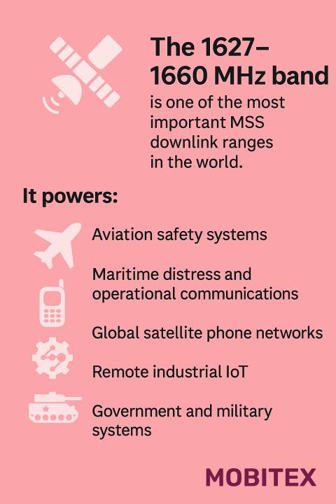
1626.5–1660.5 MHz
Band Group
L‑Band RNSS
🌐 Summary
The 1633 MHz allocation is part of the L‑Band RNSS spectrum. This range is used worldwide for critical applications that keep our communications and infrastructure running smoothly. On this page we highlight how each band is applied in real systems, from regulatory assignments to everyday devices. Our goal is to make spectrum data clear and practical for engineers, regulators, and enthusiasts alike.
Key uses of this band include: 1633 MHz is part of the Mobile‑Satellite Service downlink band used by Iridium and Globalstar for satellite communications to user terminals. Signals are space‑to‑Earth and must control out‑of‑band emissions to protect nearby Radio Astronomy allocations above 1660.5 MHz..
Core GNSS navigation band; critical for global PNT services.
🔍 Explore the full RF Spectrum database
📡 Band & Geometry key
| Field | Value |
|---|---|
| Wavelength (m) | 0.18358386895285 |
| Waveforms | BPSK(1), BOC(1,1), MBOC – per system specs |
| Antenna Form Factor (Typical) | Passive or active patch (25–35 mm), helical, or chip antenna tuned for ~1575 MHz. |
| Band Family | L‑Band MSS Downlink (1626.5–1660.5 MHz) |
| Band | L‑Band |
| Primary Common Name | Mobile‑Satellite Downlink (MSS DL) |
| FSPL @ 1 km [dB] | 96.3 |
| FSPL @ 10 km [dB] | 116.3 |
| Fresnel Radius @ 1 km (m) | 0.21430129707433 |
| Band Group | L‑Band RNSS |
| Tax Band Family | L‑Band |
| Tax Band Class | 1627 MHz – 1660 MHz L-Band Mobile Satellite Downlink |
🧩 Applications & Usage
| Field | Value |
|---|---|
| Primary Application | Satellite voice and data downlinks (Iridium, Globalstar) |
| Lower Neighbor Use | MSS Uplink (1610–1626.5 MHz) |
| Upper Neighbor Use | Allocations above 1660.5 MHz (incl. Radio Astronomy) |
| Typical Services Devices | Satellite phones, MSS terminals, maritime/aviation satcom receivers, IoT satellite modems |
| Market Common Devices | Satellite phones, gateways, IoT receivers |
| Refarming Use | Not applicable – protected RNSS band |
| Device Ecosystem Size | >10 billion GNSS-capable devices globally |
| Device Hotspots (MHz) | 1575.42 (GPS/Galileo), 1602 (GLONASS), 1561 (BeiDou) |
| Device Category | Consumer, automotive, aviation, maritime, IoT, military receivers |
| Typical Use Cases | Positioning, navigation, timing (PNT) for civilian and military systems |
| Modulation (Device) | Spread‑spectrum DSSS/BOC family: GPS L1 C/A (BPSK(1) 1.023 Mcps), Galileo E1 (CBOC/MBOC), GLONASS G1 (BPSK/FM‑CDMA), BeiDou B1 (BPSK(2)/BOC). |
| Channel Width (Device) [kHz] | ~2000–4000 kHz main‑lobe equivalent (receiver bandwidths vary 2–24 MHz by design) |
| Device Region Profiles | Global profile; multi‑GNSS (GPS, Galileo, GLONASS, BeiDou) enabled by default. |
| Per-Region EIRP Or Duty (Device) | N/A – receivers only; no transmit EIRP or duty cycle. |
| Allocation Relevance (Device) | Critical: RNSS allocation defines protected receive‑only operation; devices must meet susceptibility thresholds. |
| Adjacent-Band Collision Risks (Device) | High risk from adjacent MSS (≤1559 MHz) and out‑of‑band cellular/ISM emitters; use SAW/ceramic filters, LNA linearity, and tight front‑end selectivity. |
| Example Devices Or Skus | u‑blox M10/M9 series, Broadcom BCM47765, Qualcomm multi‑GNSS chipsets, Trimble/Septentrio receivers, timing modules (OCXO‑disciplined). |
| Common Protocols | Proprietary MSS air interfaces (Iridium, Globalstar) |
🗒️ Notes
| Field | Value |
|---|---|
| Receiver Selectivity Notes | Receiver selectivity should mitigate strong adjacent-channel MSS uplink emissions; consider site coordination near RAS facilities. |
| Interference Notes | Focus on out-of-band emissions into adjacent MSS uplink and passive services; coordination may be required near radio astronomy sites. |
| Compatibility Risk Notes | 0 |
| Notes | Core GNSS navigation band; critical for global PNT services. |
| Propagation Notes | Free-space propagation dominated; global satellite visibility required |
⚙️ Technical Rules
| Field | Value |
|---|---|
| Lower Band Frequency Limit | 1626.5 |
| Upper Band Frequency Limit | 1660.5 |
| EIRP Indoor Limits | Not applicable – receive-only band |
| EIRP Outdoor Limits | Not applicable – receive-only band |
| PSD Limit | Not applicable – receive-only band |
| Emission Mask Class | Operator/regulator-defined; prioritize low OOBE into MSS uplink and passive bands |
| Guardband Minimum [kHz] | N/A – receive-only band |
| Typical Bandwidths | 12.5 kHz–5 MHz (system‑dependent) |
| Autocalculated Bandlimits | 0 |
| Typical Bandwidths (Estimated) | 12.5 kHz–5 MHz (system‑dependent) |
| Max EIRP [dBm] | N/A – receivers only; no transmit EIRP or duty cycle. |
| Power Source Or Duty Profile (Typical) | Receiver‑side only; duty driven by application (tracking vs. timing holdover). |
| Channelization Plan | Defined by each GNSS constellation (GPS, Galileo, GLONASS, BeiDou) |
| Channelization | Continuous navigation carrier signals (BPSK, BOC, MBOC) |
| Guard Band Requirement | Strict emission masks to protect adjacent RNSS signals |
| OOB Emission Limit [dBm/MHz] | Strict OOBE < −60 dBm/MHz to protect adjacent MSS uplink and nearby passive services (e.g., RAS) |
| Spurious Emission Limit (dBm) | ≤ −60 dBm/MHz (strict protection for adjacent services; follow applicable ITU/ETSI limits) |
| RX Blocking Min [dBm] | N/A – passive receiver |
| Duplexing | Downlink (space‑to‑Earth) |
| Duplexing Information | Downlink (space‑to‑Earth) |
| Uplink Pairing | Not applicable – unpaired downlink only (space-to-Earth) |
| Downlink Pairing | Not applicable – unpaired downlink only (space-to-Earth) |
| Paired Band Info | Not applicable – receive-only RNSS band |
| Max EIRP [dBm] | N/A – receive-only band |
| Channelization Block Size | Operator carriers (kHz–MHz) |
| 3GPP Band Number | |
| Example 3GPP Bands | Not applicable – no 3GPP/LTE/NR band association |
| LTE Uplink Bands | Not applicable – no 3GPP/LTE/NR band association |
| LTE Downlink Bands | Not applicable – no 3GPP/LTE/NR band association |
| NR Uplink Bands | Not applicable – no 3GPP/LTE/NR band association |
| NR Downlink Bands | Not applicable – no 3GPP/LTE/NR band association |
| Guard Bands | ≥2–4 MHz below 1559 MHz to protect RNSS |
| Protocol Or Standard | GPS ICD-200, Galileo OS SIS ICD, GLONASS ICD, BeiDou ICD |
🌎 Country Overrides
| Field | Value |
|---|---|
| Tax Service Category | Mobile Satellite |
| Tax License Type | Licensed MSS |
| Tax Regions | Global (MSS – Inmarsat, Iridium, regional MSS operators) |
| ITU Region 1 (Europe, Africa, Middle East (west of Persian Gulf), Western Russia & Mongolia) | Mobile‑satellite (space‑to‑Earth) |
| ITU Region 2 (North America, South America, Central America, Caribbean, Greenland, Eastern Pacific Islands (Americas region)) | Mobile‑satellite (space‑to‑Earth) |
| ITU Region 3 (Asia, Australia, Pacific Islands, Oceania, Indian Subcontinent, East Asia & Southeast Asia) | Mobile‑satellite (space‑to‑Earth) |
| License Type | Licensed MSS |
| Primary Application | Satellite voice and data downlinks (Iridium, Globalstar) |
| Primary Services | User terminal reception, broadcast/messaging, paging |
| Spurious Emission [dBm] | ≤ −60 dBm/MHz (strict protection for adjacent services; follow applicable ITU/ETSI limits) |
| Lower Neighbor Use | MSS Uplink (1610–1626.5 MHz) |
| Upper Neighbor Use | Allocations above 1660.5 MHz (incl. Radio Astronomy) |
| Licensing Model | ITU‑coordinated; operator licenses |
| Typical Services Devices | Satellite phones, MSS terminals, maritime/aviation satcom receivers, IoT satellite modems |
| US FCC Alloc | Mobile-satellite service (space-to-Earth)– |
| CA IC Alloc | Mobile-satellite service (space-to-Earth)– |
| UK Ofcom Alloc | Mobile-satellite service (space-to-Earth)– |
| US Ref | ITU‑R M.1902 / M.2012 – GNSS performance standards |
| Typical Bandwidths | 12.5 kHz–5 MHz (system‑dependent) |
| Market Licensing Model | Licensed spectrum – coordinated via ITU / satellite operator agreements |
| Market Common Devices | Satellite phones, gateways, IoT receivers |
| Fresnel Radius (1st, 1 km) [m] | 0.21430129707433 |
| Typical Bandwidths (Estimated) | 12.5 kHz–5 MHz (system‑dependent) |
| Auction Status | Not auctioned – globally allocated to RNSS |
| Refarming Use | Not applicable – protected RNSS band |
| Typical Site Spacing km | N/A – space segment with global footprint. / N/A – space segment with global footprint. |
| Device Ecosystem Size | >10 billion GNSS-capable devices globally |
| Traffic Load Share | N/A – receive-only service |
| Device Hotspots (MHz) | 1575.42 (GPS/Galileo), 1602 (GLONASS), 1561 (BeiDou) |
| Device Category | Consumer, automotive, aviation, maritime, IoT, military receivers |
| Typical Use Cases | Positioning, navigation, timing (PNT) for civilian and military systems |
| Typical Center Frequencies [MHz] | 1561.098, 1575.42, 1602 |
| Rule Part (Fcc Or Region) | International: ITU‑R Radio Regulations (RNSS, space‑to‑Earth); National tables allocate RNSS; receivers typically Part 15 (unintentional). |
| Modulation (Device) | Spread‑spectrum DSSS/BOC family: GPS L1 C/A (BPSK(1) 1.023 Mcps), Galileo E1 (CBOC/MBOC), GLONASS G1 (BPSK/FM‑CDMA), BeiDou B1 (BPSK(2)/BOC). |
| Channel Width (Device) [kHz] | ~2000–4000 kHz main‑lobe equivalent (receiver bandwidths vary 2–24 MHz by design) |
| Device Region Profiles | Global profile; multi‑GNSS (GPS, Galileo, GLONASS, BeiDou) enabled by default. |
| Per-Region EIRP Or Duty (Device) | N/A – receivers only; no transmit EIRP or duty cycle. |
| Allocation Relevance (Device) | Critical: RNSS allocation defines protected receive‑only operation; devices must meet susceptibility thresholds. |
| Adjacent-Band Collision Risks (Device) | High risk from adjacent MSS (≤1559 MHz) and out‑of‑band cellular/ISM emitters; use SAW/ceramic filters, LNA linearity, and tight front‑end selectivity. |
| Example Devices Or Skus | u‑blox M10/M9 series, Broadcom BCM47765, Qualcomm multi‑GNSS chipsets, Trimble/Septentrio receivers, timing modules (OCXO‑disciplined). |
| Antenna Form Factor (Typical) | Passive or active patch (25–35 mm), helical, or chip antenna tuned for ~1575 MHz. |
| Power Source Or Duty Profile (Typical) | Receiver‑side only; duty driven by application (tracking vs. timing holdover). |
🛡️ Regulatory & Neighbors
| Field | Value |
|---|---|
| Lower Band Frequency Limit | 1626.5 |
| Upper Band Frequency Limit | 1660.5 |
| Rx Blocking Min dBm | N/A – passive receiver |
| Lower Neighbor Use | MSS Uplink (1610–1626.5 MHz) |
| Upper Neighbor Use | Allocations above 1660.5 MHz (incl. Radio Astronomy) |
| Lower Neighbor Band | MSS Uplink |
| Lower Neighbor Range | 1610–1626.5 MHz |
| Upper Neighbor Label | RAS / MetSat / other (region‑specific) |
| Upper Neighbor Range | 1660.5–1675 MHz (regional allocations vary) |
| Adjacent-Band Collision Risks (Device) | High risk from adjacent MSS (≤1559 MHz) and out‑of‑band cellular/ISM emitters; use SAW/ceramic filters, LNA linearity, and tight front‑end selectivity. |
| Real-World Range (Indoor/Outdoor) | Outdoor sky view: global coverage; indoor: limited – assisted GNSS or repeaters required. |
| US FCC Alloc | Mobile-satellite service (space-to-Earth)Mobile-satellite service (space-to-Earth) |
| CA IC Alloc | Mobile-satellite service (space-to-Earth)Mobile-satellite service (space-to-Earth) |
| UK Ofcom Alloc | Mobile-satellite service (space-to-Earth)Mobile-satellite service (space-to-Earth) |
| Regulatory References | US: ITU‑R M.1902 / M.2012 – GNSS performance standards; CA: ITU‑R M.1902 / M.2012 – GNSS performance standards; UK: ITU‑R M.1902 / M.2012 – GNSS performance standards |
| Global Harmonization | Fully global (GPS, Galileo, GLONASS, BeiDou) |
| Crossborder Coordination | None required – international GNSS spectrum coordination under ITU-R |
| Sharing Mechanism | Passive coexistence only; no active sharing permitted |
| Auction Status | Not auctioned – globally allocated to RNSS |
| Guard Or Pair | Unpaired RNSS downlink (space-to-Earth) |
📈 Market & Measurements
| Field | Value |
|---|---|
| Noise Floor | Satellite downlink (space-to-Earth); GEO/MEO/LEO systems |
| Interference Cases | Protect adjacent MSS uplink (1610–1626.5 MHz) and nearby passive services (e.g., RAS at 1610.6–1613.8 MHz); strict OOBE/spurious limits recommended. |
| Lower Neighbor Range | 1610–1626.5 MHz |
| Upper Neighbor Range | 1660.5–1675 MHz (regional allocations vary) |
| Interference Notes | Focus on out-of-band emissions into adjacent MSS uplink and passive services; coordination may be required near radio astronomy sites. |
| Market Licensing Model | Licensed spectrum – coordinated via ITU / satellite operator agreements |
| Market Commercial Value | High – ubiquitous GNSS receiver ecosystem; critical PNT infrastructure |
| Market Common Devices | Satellite phones, gateways, IoT receivers |
| Market Deployment Density | Medium – global satellite coverage |
| Noise Floor (Estimated) | Satellite downlink (space-to-Earth); GEO/MEO/LEO systems |
| Market Commercial Value (Estimated) | High – ubiquitous GNSS receiver ecosystem; critical PNT infrastructure |
| Ecosystem Maturity | Fully mature global ecosystem (>10B receivers) |
| Indoor Penetration | Weak; GNSS signals ~−130 dBm require outdoor or assisted GNSS |
| Known Interference | Vulnerable to jamming/spoofing; mitigation via multi-GNSS and SAASM/RTK |
| Device Ecosystem Size | >10 billion GNSS-capable devices globally |
| Real-World Range (Indoor/Outdoor) | Outdoor sky view: global coverage; indoor: limited – assisted GNSS or repeaters required. |
| Antenna Form Factor (Typical) | Passive or active patch (25–35 mm), helical, or chip antenna tuned for ~1575 MHz. |
| Ecosystem Maturity | Fully mature global ecosystem (>10B receivers) |
| Device Ecosystem Size | >10 billion GNSS-capable devices globally |
| Chipset Availability | Universal; all modern chipsets support multi-GNSS L1/E1 |
| Operator Deployments | Global constellation operators (US, EU, Russia, China, Japan, India) |
| Technology Generations Deployed | GPS L1 C/A, Galileo E1 OS, GLONASS G1, BeiDou B1I/B1C |
| Roaming Support | Universal cross-system compatibility via multi-GNSS receivers |
| Traffic Load Share | N/A – receive-only service |
| Indoor Penetration | Weak; GNSS signals ~−130 dBm require outdoor or assisted GNSS |
| Known Interference | Vulnerable to jamming/spoofing; mitigation via multi-GNSS and SAASM/RTK |
| Occupancy | Moderate to high – MSS downlink activity (operator-dependent) |
| Occupancy Bucket Pct | >95% global utilization (GNSS receivers ubiquitous) |
| Latency Profile | Deterministic; satellite signal propagation delay ~67 ms (20,200 km) |
| Common Channels Or Profiles | GPS L1 C/A, Galileo E1, GLONASS G1, BeiDou B1 |
| Security Features | Civil signals: Navigation message authentication (Galileo OSNMA), multi‑GNSS cross‑checks; Military: encrypted P(Y)/M‑code (not publicly specified). |
| Lbt Or Fhss Requirement | Not applicable – receive‑only RNSS band (no LBT/FHSS). |
| Popularity (Installed Base) | Extremely high – billions of active receivers worldwide. |
| Coexistence Tips | Add pre‑selector/SAW filters; ensure antenna clear sky view; mitigate jammers/spoofers; multi‑GNSS fusion and carrier‑phase techniques (RTK/PPP) for resilience. |
| Latency Class | Initial TTFF: ~1–30 s (cold‑start); steady‑state navigation latency <1 s. |
| Device Hotspots (Scoped && Tagged) | 1575.42 (GPS/Galileo), 1602 (GLONASS), 1561 (BeiDou). |