Frequency
1674 MHz
Range
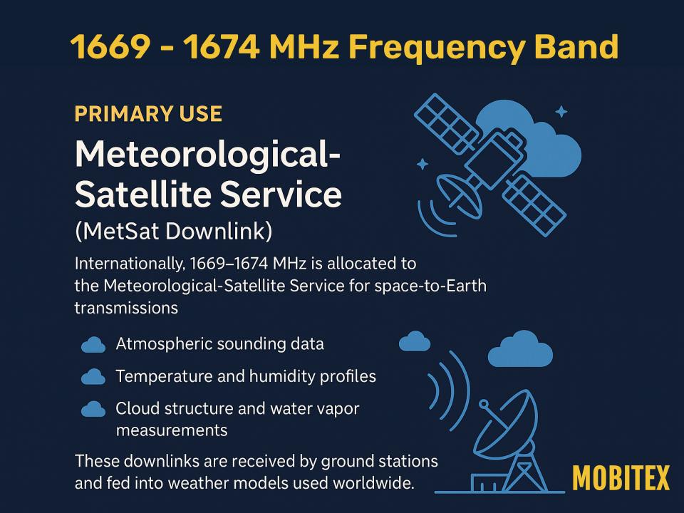
1669–1674 MHz
Band Group
L-Band Meteorological Satellite
🌐 Summary
The 1674 MHz allocation is part of the L-Band Meteorological Satellite spectrum. This range is used worldwide for critical applications that keep our communications and infrastructure running smoothly. On this page we highlight how each band is applied in real systems, from regulatory assignments to everyday devices. Our goal is to make spectrum data clear and practical for engineers, regulators, and enthusiasts alike.
Key uses of this band include: 1674 MHz is part of a region‑specific L‑band downlink segment that commonly supports meteorological‑satellite and related services. Operations must coordinate with national allocations and protect adjacent Radio Astronomy and satellite services..
N/A (mission-specific satellite downlink)
🔍 Explore the full RF Spectrum database
📡 Band & Geometry key
| Field | Value |
|---|---|
| Wavelength (m) | 0.17908748984468 |
| Waveforms | BPSK(1), BOC(1,1), MBOC – per system specs |
| Antenna Form Factor (Typical) | Passive or active patch (25–35 mm), helical, or chip antenna tuned for ~1575 MHz. |
| Band Family | L‑Band MSS Downlink (1626.5–1660.5 MHz) |
| Band | L‑Band |
| Primary Common Name | Meteorological-Satellite (MetSat) downlink |
| FSPL @ 1 km [dB] | 96.3 |
| FSPL @ 10 km [dB] | 116.3 |
| Fresnel Radius @ 1 km (m) | 0.212 |
| Band Group | L-Band Meteorological Satellite |
| Tax Band Family | L‑Band |
| Tax Band Class | 1669 MHz – 1674 MHz L-Band Meteorological-Satellite Service |
🧩 Applications & Usage
| Field | Value |
|---|---|
| Primary Application | Meteorological satellite downlink (weather & Earth observation) |
| Lower Neighbor Use | RAS below 1668.4 MHz and MSS DL below 1660.5 MHz |
| Upper Neighbor Use | Allocations above 1675 MHz (regional) |
| Typical Services Devices | Meteorological satellite payloads; ground receiving stations; weather agency downlink receivers; environmental monitoring networks. |
| Market Common Devices | Satellite phones, gateways, IoT receivers |
| Refarming Use | Not applicable (satellite scientific/operational allocation) |
| Device Ecosystem Size | Specialized (weather agencies, ground stations, satellite operators) |
| Device Hotspots (MHz) | N/A (mission-specific satellite downlink) |
| Device Category | Consumer, automotive, aviation, maritime, IoT, military receivers |
| Typical Use Cases | Atmospheric sounding data; temperature & humidity profiles; cloud structure and water vapor measurements; weather model ingestion. |
| Modulation (Device) | N/A (mission-specific satellite downlink) |
| Channel Width (Device) [kHz] | ~2000–4000 kHz main‑lobe equivalent (receiver bandwidths vary 2–24 MHz by design) |
| Device Region Profiles | N/A (mission-specific satellite downlink) |
| Per-Region EIRP Or Duty (Device) | N/A – receivers only; no transmit EIRP or duty cycle. |
| Allocation Relevance (Device) | N/A (mission-specific satellite downlink) |
| Adjacent-Band Collision Risks (Device) | High risk from adjacent MSS (≤1559 MHz) and out‑of‑band cellular/ISM emitters; use SAW/ceramic filters, LNA linearity, and tight front‑end selectivity. |
| Example Devices Or Skus | N/A (mission-specific satellite downlink) |
| Common Protocols | Proprietary MSS air interfaces (Iridium, Globalstar) |
🗒️ Notes
| Field | Value |
|---|---|
| Receiver Selectivity Notes | High selectivity (≥60 dB rejection across 1559–1610 MHz) |
| Interference Notes | Critical weather data downlinks. Protect adjacent Radio Astronomy band (1661–1668 MHz) via strict out-of-band emission limits and coordination. |
| Compatibility Risk Notes | 0 |
| Notes | N/A (mission-specific satellite downlink) |
| Propagation Notes | Free-space propagation dominated; global satellite visibility required |
⚙️ Technical Rules
| Field | Value |
|---|---|
| Lower Band Frequency Limit | 1669 |
| Upper Band Frequency Limit | 1674 |
| EIRP Indoor Limits | Not applicable – receive-only band |
| EIRP Outdoor Limits | Not applicable – receive-only band |
| PSD Limit | Not applicable – receive-only band |
| Emission Mask Class | Satellite downlink emission masks per operator/regulator; designed to protect adjacent RAS |
| Guardband Minimum [kHz] | N/A – receive-only band |
| Typical Bandwidths | 12.5 kHz–5 MHz (system‑dependent) |
| Autocalculated Bandlimits | 0 |
| Typical Bandwidths (Estimated) | 12.5 kHz–5 MHz (system‑dependent) |
| Max EIRP [dBm] | N/A – receivers only; no transmit EIRP or duty cycle. |
| Power Source Or Duty Profile (Typical) | Receiver‑side only; duty driven by application (tracking vs. timing holdover). |
| Channelization Plan | N/A (mission-specific satellite downlink) |
| Channelization | No consumer channel plan; mission-specific downlink assignments coordinated internationally. |
| Guard Band Requirement | N/A (mission-specific satellite downlink) |
| OOB Emission Limit [dBm/MHz] | Strict out-of-band emission limits to protect adjacent 1661–1668 MHz Radio Astronomy Service (RAS). |
| Spurious Emission Limit (dBm) | Spurious and OOB emissions tightly controlled to protect RAS and adjacent services (mission/regulator dependent). |
| RX Blocking Min [dBm] | N/A – passive receiver |
| Duplexing | N/A (Satellite downlink) |
| Duplexing Information | N/A (Satellite downlink) |
| Uplink Pairing | Not applicable – unpaired downlink only (space-to-Earth) |
| Downlink Pairing | Not applicable – unpaired downlink only (space-to-Earth) |
| Paired Band Info | N/A (mission-specific satellite downlink) |
| Max EIRP [dBm] | N/A – receive-only band |
| Channelization Block Size | Operator carriers (kHz–MHz) |
| 3GPP Band Number | |
| Example 3GPP Bands | Not applicable – no 3GPP/LTE/NR band association |
| LTE Uplink Bands | Not applicable – no 3GPP/LTE/NR band association |
| LTE Downlink Bands | Not applicable – no 3GPP/LTE/NR band association |
| NR Uplink Bands | Not applicable – no 3GPP/LTE/NR band association |
| NR Downlink Bands | Not applicable – no 3GPP/LTE/NR band association |
| Guard Bands | N/A (mission-specific satellite downlink) |
| Protocol Or Standard | Mission-specific telemetry/downlink formats (satellite operator/agency specific); no public consumer protocol. |
🌎 Country Overrides
| Field | Value |
|---|---|
| Tax Service Category | Earth Observation / Weather Satellite |
| Tax License Type | Licensed / coordinated (space service) |
| Tax Regions | Global (ITU Regions 1–3) |
| ITU Region 1 (Europe, Africa, Middle East (west of Persian Gulf), Western Russia & Mongolia) | Meteorological-satellite service (space-to-Earth) |
| ITU Region 2 (North America, South America, Central America, Caribbean, Greenland, Eastern Pacific Islands (Americas region)) | Meteorological-satellite service (space-to-Earth) |
| ITU Region 3 (Asia, Australia, Pacific Islands, Oceania, Indian Subcontinent, East Asia & Southeast Asia) | Meteorological-satellite service (space-to-Earth) |
| License Type | Licensed / coordinated — region‑specific |
| Primary Application | Meteorological satellite downlink (weather & Earth observation) |
| Primary Services | Weather imagery and data; regional satellite links |
| Spurious Emission [dBm] | Spurious and OOB emissions tightly controlled to protect RAS and adjacent services (mission/regulator dependent). |
| Lower Neighbor Use | RAS below 1668.4 MHz and MSS DL below 1660.5 MHz |
| Upper Neighbor Use | Allocations above 1675 MHz (regional) |
| Licensing Model | ITU‑coordinated; operator licenses |
| Typical Services Devices | Meteorological satellite payloads; ground receiving stations; weather agency downlink receivers; environmental monitoring networks. |
| US FCC Alloc | Meteorological-satellite service (space-to-Earth)– |
| CA IC Alloc | Meteorological-satellite service (space-to-Earth)– |
| UK Ofcom Alloc | Meteorological-satellite service (space-to-Earth)– |
| US Ref | N/A (mission-specific satellite downlink) |
| Typical Bandwidths | 12.5 kHz–5 MHz (system‑dependent) |
| Market Licensing Model | Licensed spectrum – coordinated via ITU / satellite operator agreements |
| Market Common Devices | Satellite phones, gateways, IoT receivers |
| Fresnel Radius (1st, 1 km) [m] | 0.212 |
| Typical Bandwidths (Estimated) | 12.5 kHz–5 MHz (system‑dependent) |
| Auction Status | Not typically auctioned as terrestrial spectrum; coordinated satellite allocations |
| Refarming Use | Not applicable (satellite scientific/operational allocation) |
| Typical Site Spacing km | N/A – space segment with global footprint. / N/A – space segment with global footprint. |
| Device Ecosystem Size | Specialized (weather agencies, ground stations, satellite operators) |
| Traffic Load Share | N/A – receive-only service |
| Device Hotspots (MHz) | N/A (mission-specific satellite downlink) |
| Device Category | Consumer, automotive, aviation, maritime, IoT, military receivers |
| Typical Use Cases | Atmospheric sounding data; temperature & humidity profiles; cloud structure and water vapor measurements; weather model ingestion. |
| Typical Center Frequencies [MHz] | N/A (mission-specific; no standardized channel plan) |
| Rule Part (Fcc Or Region) | Satellite services regulations (jurisdiction-specific); emissions must protect RAS below 1668 MHz |
| Modulation (Device) | N/A (mission-specific satellite downlink) |
| Channel Width (Device) [kHz] | ~2000–4000 kHz main‑lobe equivalent (receiver bandwidths vary 2–24 MHz by design) |
| Device Region Profiles | N/A (mission-specific satellite downlink) |
| Per-Region EIRP Or Duty (Device) | N/A – receivers only; no transmit EIRP or duty cycle. |
| Allocation Relevance (Device) | N/A (mission-specific satellite downlink) |
| Adjacent-Band Collision Risks (Device) | High risk from adjacent MSS (≤1559 MHz) and out‑of‑band cellular/ISM emitters; use SAW/ceramic filters, LNA linearity, and tight front‑end selectivity. |
| Example Devices Or Skus | N/A (mission-specific satellite downlink) |
| Antenna Form Factor (Typical) | Passive or active patch (25–35 mm), helical, or chip antenna tuned for ~1575 MHz. |
| Power Source Or Duty Profile (Typical) | Receiver‑side only; duty driven by application (tracking vs. timing holdover). |
🛡️ Regulatory & Neighbors
| Field | Value |
|---|---|
| Lower Band Frequency Limit | 1669 |
| Upper Band Frequency Limit | 1674 |
| Rx Blocking Min dBm | N/A – passive receiver |
| Lower Neighbor Use | RAS below 1668.4 MHz and MSS DL below 1660.5 MHz |
| Upper Neighbor Use | Allocations above 1675 MHz (regional) |
| Lower Neighbor Band | RAS / MSS |
| Lower Neighbor Range | 1660.5–1668.4 / 1626.5–1660.5 MHz |
| Upper Neighbor Label | MetSat / regional (varies) |
| Upper Neighbor Range | 1675–1695 MHz (MetSat in many regions) |
| Adjacent-Band Collision Risks (Device) | High risk from adjacent MSS (≤1559 MHz) and out‑of‑band cellular/ISM emitters; use SAW/ceramic filters, LNA linearity, and tight front‑end selectivity. |
| Real-World Range (Indoor/Outdoor) | N/A (satellite downlink coverage; depends on satellite footprint and ground receiver design) |
| US FCC Alloc | Meteorological-satellite service (space-to-Earth)Meteorological-satellite service (space-to-Earth) |
| CA IC Alloc | Meteorological-satellite service (space-to-Earth)Meteorological-satellite service (space-to-Earth) |
| UK Ofcom Alloc | Meteorological-satellite service (space-to-Earth)Meteorological-satellite service (space-to-Earth) |
| Regulatory References | US: N/A (mission-specific satellite downlink); CA: N/A (mission-specific satellite downlink); UK: N/A (mission-specific satellite downlink) |
| Global Harmonization | N/A (mission-specific satellite downlink) |
| Crossborder Coordination | International coordination required (ITU filings; operator coordination); protect adjacent RAS |
| Sharing Mechanism | Passive coexistence only; no active sharing permitted |
| Auction Status | Not typically auctioned as terrestrial spectrum; coordinated satellite allocations |
| Guard Or Pair | N/A (mission-specific satellite downlink) |
📈 Market & Measurements
| Field | Value |
|---|---|
| Noise Floor | Satellite downlink (space-to-Earth); GEO/MEO/LEO systems |
| Interference Cases | N/A (mission-specific satellite downlink) |
| Lower Neighbor Range | 1660.5–1668.4 / 1626.5–1660.5 MHz |
| Upper Neighbor Range | 1675–1695 MHz (MetSat in many regions) |
| Interference Notes | Critical weather data downlinks. Protect adjacent Radio Astronomy band (1661–1668 MHz) via strict out-of-band emission limits and coordination. |
| Market Licensing Model | Licensed spectrum – coordinated via ITU / satellite operator agreements |
| Market Commercial Value | N/A (mission-specific satellite downlink) |
| Market Common Devices | Satellite phones, gateways, IoT receivers |
| Market Deployment Density | Medium – global satellite coverage |
| Noise Floor (Estimated) | Satellite downlink (space-to-Earth); GEO/MEO/LEO systems |
| Market Commercial Value (Estimated) | N/A (mission-specific satellite downlink) |
| Ecosystem Maturity | Fully mature global ecosystem (>10B receivers) |
| Indoor Penetration | N/A (mission-specific satellite downlink) |
| Known Interference | N/A (mission-specific satellite downlink) |
| Device Ecosystem Size | Specialized (weather agencies, ground stations, satellite operators) |
| Real-World Range (Indoor/Outdoor) | N/A (satellite downlink coverage; depends on satellite footprint and ground receiver design) |
| Antenna Form Factor (Typical) | Passive or active patch (25–35 mm), helical, or chip antenna tuned for ~1575 MHz. |
| Ecosystem Maturity | Fully mature global ecosystem (>10B receivers) |
| Device Ecosystem Size | Specialized (weather agencies, ground stations, satellite operators) |
| Chipset Availability | N/A (mission-specific satellite downlink) |
| Operator Deployments | Global constellation operators (US, EU, Russia, China, Japan, India) |
| Technology Generations Deployed | N/A (satellite mission dependent) |
| Roaming Support | N/A |
| Traffic Load Share | N/A – receive-only service |
| Indoor Penetration | N/A (mission-specific satellite downlink) |
| Known Interference | N/A (mission-specific satellite downlink) |
| Occupancy | Variable (mission-dependent); continuous reception at ground stations during passes/coverage |
| Occupancy Bucket Pct | N/A (mission-specific satellite downlink) |
| Latency Profile | Deterministic; satellite signal propagation delay ~67 ms (20,200 km) |
| Common Channels Or Profiles | N/A (mission-specific downlinks; no standardized channel plan) |
| Security Features | Mission-dependent; many systems use encryption/authentication for telemetry |
| Lbt Or Fhss Requirement | N/A (mission-specific satellite downlink) |
| Popularity (Installed Base) | Extremely high – billions of active receivers worldwide. |
| Coexistence Tips | Ensure strict OOBE compliance; protect 1661–1668 MHz RAS; coordinate ground stations and satellite operations |
| Latency Class | N/A (mission-specific satellite downlink) |
| Device Hotspots (Scoped && Tagged) | N/A (mission-specific satellite downlink) |