Frequency
1231 MHz
Range
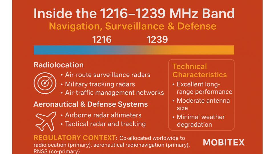
1215–1240 MHz
Band Group
L-Band Radiolocation (1215–1300 MHz) — Coexistence Zone
🌐 Summary
The 1231 MHz allocation is part of the L-Band Radiolocation (1215–1300 MHz) — Coexistence Zone spectrum. This range is used worldwide for critical applications that keep our communications and infrastructure running smoothly. On this page we highlight how each band is applied in real systems, from regulatory assignments to everyday devices. Our goal is to make spectrum data clear and practical for engineers, regulators, and enthusiasts alike.
Key uses of this band include: Part of the L‑band shared by radiolocation/aeronautical radionavigation and RNSS. Includes GPS L2 at 1227.6 MHz. Receivers are ubiquitous; transmit radar is licensed and localized. Careful coexistence required with 23 cm amateur band above 1240 MHz..
Includes GPS L2 center 1227.6 MHz; careful coexistence with 23 cm amateur band above 1240 MHz
Overview
🔍 Explore the full RF Spectrum database
📡 Band & Geometry key
| Field | Value |
|---|---|
| Wavelength (m) | 0.243536 |
| Waveforms | Pulsed radar; BPSK/QPSK (RNSS) |
| Antenna Form Factor (Typical) | Patch/ceramic for GNSS; directional dishes/arrays for radar |
| Band Family | Radiolocation / L‑Band |
| Band | 1215–1300 MHz Radiolocation & Shared Services (coexistence zone with Amateur/Satellite) |
| Primary Common Name | L-band |
| FSPL @ 1 km [dB] | 94.25 |
| FSPL @ 10 km [dB] | 114.25 |
| Fresnel Radius @ 1 km (m) | 7.803 |
| Band Group | L-Band Radiolocation (1215–1300 MHz) — Coexistence Zone |
| Tax Band Family | UHF/L-band Transition |
| Tax Band Class | 1215 MHz – 1240 MHz UHF/L-band Transition Radiolocation |
🧩 Applications & Usage
| Field | Value |
|---|---|
| Primary Application | Radiolocation / radar (ground, airborne, ATC); coordination with adjacent services |
| Lower Neighbor Use | Aeronautical Radionavigation (≥1215 MHz) |
| Upper Neighbor Use | Amateur (23 cm) & RNSS (≥1240 MHz) |
| Typical Services Devices | GNSS receivers (GPS L2 1227.6 MHz), radar altimeters, avionics radar |
| Market Common Devices | GNSS modules, avionics equipment, radar systems |
| Refarming Use | Not typical (safety/space services) |
| Device Ecosystem Size | Very large for GNSS; niche radar |
| Device Hotspots (MHz) | 1227.6 |
| Device Category | GNSS receiver / Aeronautical radar |
| Typical Use Cases | Civil/aviation navigation, timing, surveillance radar |
| Modulation (Device) | BPSK/QPSK (GNSS); radar pulse/FMCW depending on system |
| Channel Width (Device) [kHz] | Wideband (GNSS spread-spectrum); radar mode-dependent |
| Device Region Profiles | Global GNSS; radar licensed per nation |
| Per-Region EIRP Or Duty (Device) | GNSS receive-only; radar duty/EIRP vary by license |
| Allocation Relevance (Device) | High for navigation; critical infrastructure |
| Adjacent-Band Collision Risks (Device) | 23 cm amateur emissions; nearby high-power radar |
| Example Devices Or Skus | u-blox/ZED‑F9x GNSS; avionics GNSS; radar altimeter systems |
| Common Protocols | GNSS spread-spectrum; radar pulse compression |
🗒️ Notes
| Field | Value |
|---|---|
| Receiver Selectivity Notes | GNSS receivers require high selectivity and filtering near 1240–1300 MHz amateur |
| Interference Notes | Coexistence requires filtering, power control, exclusion zones near radar sites |
| Compatibility Risk Notes | High sensitivity RNSS receivers adjacent to 23 cm amateur; manage desense |
| Notes | Includes GPS L2 center 1227.6 MHz; careful coexistence with 23 cm amateur band above 1240 MHz |
| Propagation Notes | Line-of-sight; modest building penetration; low rain fade; LOS planning needed |
⚙️ Technical Rules
| Field | Value |
|---|---|
| Lower Band Frequency Limit | 1215 |
| Upper Band Frequency Limit | 1240 |
| EIRP Indoor Limits | Not typically applicable (receivers); transmitters are licensed/coordinated radar |
| EIRP Outdoor Limits | Varies by administration; radar site-specific licensing |
| PSD Limit | Varies by administration; emission constraints near RNSS |
| Emission Mask Class | Service-specific (radar/RNSS) |
| Guardband Minimum [kHz] | 1000 |
| Typical Bandwidths | 1–20 MHz (radar); 1–20 MHz (GNSS spread-spectrum) |
| Autocalculated Bandlimits | 1215.0–1240.0 MHz |
| Typical Bandwidths (Estimated) | 1–20 MHz (radar); 1–20 MHz (GNSS spread-spectrum) |
| Max EIRP [dBm] | GNSS receive-only; radar duty/EIRP vary by license |
| Power Source Or Duty Profile (Typical) | GNSS low-power receive; radar high-power low duty-cycle pulses |
| Channelization Plan | Not channelized; service-specific waveforms |
| Channelization | Continuous / wideband; pulsed for radar; spread-spectrum for RNSS |
| Guard Band Requirement | ≈1 MHz near 1240 MHz boundary (coexistence) |
| OOB Emission Limit [dBm/MHz] | Strict OOBE to protect RNSS bands |
| Spurious Emission Limit (dBm) | As per national rules; protect safety services |
| RX Blocking Min [dBm] | High-GNSS immunity required in 23 cm adjacency |
| Duplexing | Unpaired |
| Duplexing Information | Unpaired allocations; downlink-only for RNSS |
| Uplink Pairing | Not applicable (unpaired RNSS/radar) |
| Downlink Pairing | Not applicable (downlink-only RNSS; radar not paired) |
| Paired Band Info | Not applicable |
| Max EIRP [dBm] | Varies by radar license; GNSS is receive-only |
| Channelization Block Size | N/A (unpaired RNSS/radar) |
| 3GPP Band Number | |
| Example 3GPP Bands | None (non‑3GPP services) |
| LTE Uplink Bands | None |
| LTE Downlink Bands | None |
| NR Uplink Bands | None |
| NR Downlink Bands | None |
| Guard Bands | Maintain ≥1 MHz internal separation between adjacent radar systems; coordinate to minimize overlap. |
| Protocol Or Standard | GNSS L2 (GPS), Galileo E5b; radar pulse compression |
🌎 Country Overrides
| Field | Value |
|---|---|
| Tax Service Category | Other / Various |
| Tax License Type | Shared / Coordinated (RNSS & Radiolocation) |
| Tax Regions | Global (ITU Regions 1/2/3) |
| ITU Region 1 (Europe, Africa, Middle East (west of Persian Gulf), Western Russia & Mongolia) | Radiolocation primary; coordination and national footnotes apply. Amateur allocations generally outside this sub‑range. |
| ITU Region 2 (North America, South America, Central America, Caribbean, Greenland, Eastern Pacific Islands (Americas region)) | Radiolocation primary; coordination and national footnotes apply. Amateur allocations generally outside this sub‑range. |
| ITU Region 3 (Asia, Australia, Pacific Islands, Oceania, Indian Subcontinent, East Asia & Southeast Asia) | Radiolocation primary; coordination and national footnotes apply. Amateur allocations generally outside this sub‑range. |
| License Type | Licensed / Service-Specific |
| Primary Application | Radiolocation / radar (ground, airborne, ATC); coordination with adjacent services |
| Primary Services | Radiolocation, surveillance radar |
| Spurious Emission [dBm] | As per national rules; protect safety services |
| Lower Neighbor Use | Aeronautical Radionavigation (≥1215 MHz) |
| Upper Neighbor Use | Amateur (23 cm) & RNSS (≥1240 MHz) |
| Licensing Model | Service-specific licensing (government/assigned); Amateur uses national amateur licensing |
| Typical Services Devices | GNSS receivers (GPS L2 1227.6 MHz), radar altimeters, avionics radar |
| US FCC Alloc | Radiolocation; Aeronautical Radionavigation; RNSS (space-to-Earth)– |
| CA IC Alloc | Radiolocation; Aeronautical Radionavigation; RNSS– |
| UK Ofcom Alloc | Radiolocation; Aeronautical Radionavigation; RNSS– |
| US Ref | FCC allocation tables (Part 2); aeronautical/radar rules (Parts 87/90) |
| Typical Bandwidths | 1–20 MHz (radar); 1–20 MHz (GNSS spread-spectrum) |
| Market Licensing Model | Not commercial spectrum; service-assigned or amateur licensing |
| Market Common Devices | GNSS modules, avionics equipment, radar systems |
| Fresnel Radius (1st, 1 km) [m] | 7.803 |
| Typical Bandwidths (Estimated) | 1–20 MHz (radar); 1–20 MHz (GNSS spread-spectrum) |
| Auction Status | Not typically auctioned (safety/space/radar services) |
| Refarming Use | Not typical (safety/space services) |
| Typical Site Spacing km | GNSS ubiquitous; radar sites sparse (10–100+ km) / GNSS ubiquitous; radar sites sparse (50–200+ km) |
| Device Ecosystem Size | Very large for GNSS; niche radar |
| Traffic Load Share | N/A (non-carrier) |
| Device Hotspots (MHz) | 1227.6 |
| Device Category | GNSS receiver / Aeronautical radar |
| Typical Use Cases | Civil/aviation navigation, timing, surveillance radar |
| Typical Center Frequencies [MHz] | 1227.6 (GPS L2) |
| Rule Part (Fcc Or Region) | Service-dependent; see national rules |
| Modulation (Device) | BPSK/QPSK (GNSS); radar pulse/FMCW depending on system |
| Channel Width (Device) [kHz] | Wideband (GNSS spread-spectrum); radar mode-dependent |
| Device Region Profiles | Global GNSS; radar licensed per nation |
| Per-Region EIRP Or Duty (Device) | GNSS receive-only; radar duty/EIRP vary by license |
| Allocation Relevance (Device) | High for navigation; critical infrastructure |
| Adjacent-Band Collision Risks (Device) | 23 cm amateur emissions; nearby high-power radar |
| Example Devices Or Skus | u-blox/ZED‑F9x GNSS; avionics GNSS; radar altimeter systems |
| Antenna Form Factor (Typical) | Patch/ceramic for GNSS; directional dishes/arrays for radar |
| Power Source Or Duty Profile (Typical) | GNSS low-power receive; radar high-power low duty-cycle pulses |
🛡️ Regulatory & Neighbors
| Field | Value |
|---|---|
| Lower Band Frequency Limit | 1215 |
| Upper Band Frequency Limit | 1240 |
| Rx Blocking Min dBm | High-GNSS immunity required in 23 cm adjacency |
| Lower Neighbor Use | Aeronautical Radionavigation (≥1215 MHz) |
| Upper Neighbor Use | Amateur (23 cm) & RNSS (≥1240 MHz) |
| Lower Neighbor Band | Aeronautical Radionavigation |
| Lower Neighbor Range | 960–1215 MHz |
| Upper Neighbor Label | Amateur (23 cm) / RNSS |
| Upper Neighbor Range | 1240–1300 MHz |
| Adjacent-Band Collision Risks (Device) | 23 cm amateur emissions; nearby high-power radar |
| Real-World Range (Indoor/Outdoor) | GNSS: global outdoors; limited indoor without repeaters |
| US FCC Alloc | Radiolocation; Aeronautical Radionavigation; RNSS (space-to-Earth)Radiolocation; Aeronautical Radionavigation; RNSS (space-to-Earth) |
| CA IC Alloc | Radiolocation; Aeronautical Radionavigation; RNSSRadiolocation; Aeronautical Radionavigation; RNSS |
| UK Ofcom Alloc | Radiolocation; Aeronautical Radionavigation; RNSSRadiolocation; Aeronautical Radionavigation; RNSS |
| Regulatory References | US: FCC allocation tables (Part 2); aeronautical/radar rules (Parts 87/90); CA: ISED Table of Frequency Allocations; aeronautical/radar SRSPs; UK: UK Frequency Allocation Table; Ofcom guidance on 23 cm/GNSS coexistence |
| Global Harmonization | Strong for RNSS (GPS/Galileo/GLONASS) |
| Crossborder Coordination | Required for radar deployments; RNSS global |
| Sharing Mechanism | Time-based coordination and geographic separation between fixed and airborne radar sites; priority for safety-of-life aeronautical systems. |
| Auction Status | Not typically auctioned (safety/space/radar services) |
| Guard Or Pair | Guard towards 1240 MHz due to 23 cm coexistence |
📈 Market & Measurements
| Field | Value |
|---|---|
| Noise Floor | Typical rural −101 to −105 dBm/Hz at L‑band receiver NF assumptions |
| Interference Cases | Radar to RNSS; Amateur 23 cm to GNSS front ends |
| Lower Neighbor Range | 960–1215 MHz |
| Upper Neighbor Range | 1240–1300 MHz |
| Interference Notes | Coexistence requires filtering, power control, exclusion zones near radar sites |
| Market Licensing Model | Not commercial spectrum; service-assigned or amateur licensing |
| Market Commercial Value | High (GNSS ecosystem); restricted for active transmitters |
| Market Common Devices | GNSS modules, avionics equipment, radar systems |
| Market Deployment Density | Global GNSS receivers; localized high-power radar sites |
| Noise Floor (Estimated) | Typical rural −101 to −105 dBm/Hz at L‑band receiver NF assumptions |
| Market Commercial Value (Estimated) | High (GNSS ecosystem); restricted for active transmitters |
| Ecosystem Maturity | Very high for GNSS; mature for aeronautical radionavigation |
| Indoor Penetration | Moderate (L‑band); building attenuation present |
| Known Interference | Potential radar-to-radar interference; coordination between fixed and airborne systems required. |
| Device Ecosystem Size | Very large for GNSS; niche radar |
| Real-World Range (Indoor/Outdoor) | GNSS: global outdoors; limited indoor without repeaters |
| Antenna Form Factor (Typical) | Patch/ceramic for GNSS; directional dishes/arrays for radar |
| Ecosystem Maturity | Very high for GNSS; mature for aeronautical radionavigation |
| Device Ecosystem Size | Very large for GNSS; niche radar |
| Chipset Availability | Broad GNSS chipset availability |
| Operator Deployments | Not operator-based (safety/space services) |
| Technology Generations Deployed | N/A (non-3GPP) |
| Roaming Support | Global GNSS availability |
| Traffic Load Share | N/A (non-carrier) |
| Indoor Penetration | Moderate (L‑band); building attenuation present |
| Known Interference | Potential radar-to-radar interference; coordination between fixed and airborne systems required. |
| Occupancy | Moderate (localized radar) / ubiquitous receive-only GNSS |
| Occupancy Bucket Pct | 40–60% (contextual) |
| Latency Profile | Real-time (radar); low-latency navigation (GNSS) |
| Common Channels Or Profiles | GNSS spread-spectrum codes (L2C/L2P(Y)); radar modes vary |
| Security Features | GNSS authentication evolving; radar has operational controls |
| Lbt Or Fhss Requirement | Not applicable (RNSS/radar) |
| Popularity (Installed Base) | Extremely high (GNSS); radar moderate |
| Coexistence Tips | Use SAW/LC filters; notch/guard near 1240+ MHz; maintain antenna isolation |
| Latency Class | GNSS navigation low-latency; radar real-time |
| Device Hotspots (Scoped && Tagged) | Airports, flight corridors, research ranges; global GNSS use |