Global Navigation Satellite Systems (GNSS) is the umbrella term for the four major satellite positioning constellations now operating worldwide: GPS (United States), Galileo (European Union), GLONASS (Russia), and BeiDou (China). Each system was designed independently, decades apart in some cases, yet they now share significant overlap in the frequencies they use. This guide breaks down exactly which frequencies each constellation occupies, why multiple bands exist per system, and why that overlap was a deliberate design choice rather than an accident.
Why GNSS Needs Multiple Bands at All
A single-frequency GPS receiver, the kind found in older car navigation units and basic smartphones, is vulnerable to a specific source of error: the ionosphere. As GNSS signals pass through the ionosphere, charged particles delay the signal by an amount that depends on frequency. A receiver using only one frequency has no way to measure or correct for this delay directly and must rely on a modeled estimate, which limits accuracy to several meters under normal conditions.
Receivers capable of tracking two or more frequencies simultaneously can compare the delay across bands and cancel out the ionospheric error almost entirely, which is why every modern GNSS constellation transmits on multiple frequencies and why high-precision survey and aviation equipment specifically advertises multi-frequency capability.
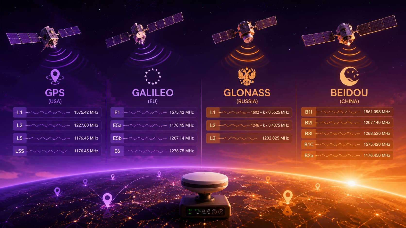
GPS (United States)
GPS, operated by the U.S. Space Force, uses three primary civilian-relevant frequencies.
L1: 1,575.42 MHz is the original and most widely used GPS frequency, broadcasting the legacy C/A code that virtually every consumer GPS chip since the 1990s has been built to receive, along with the newer civilian L1C signal designed for improved interoperability with other constellations.
L2: 1,227.6 MHz originally carried only the encrypted military P(Y) code, but newer satellites also broadcast L2C, a civilian signal added specifically to give civilian receivers a second frequency for ionospheric correction without needing access to the encrypted military signal.
L5: 1,176.45 MHz is the newest GPS civil signal, designed for safety-of-life applications like aviation. It uses higher transmission power and a more robust signal structure than L1 or L2, making it more resistant to interference and multipath errors in dense urban environments.
A fourth band, L3 at 1,381.05 MHz, exists but is used exclusively for the Nuclear Detonation Detection System and is not relevant to positioning receivers. Military-only signals also occupy the L1 and L2 bands using the M-code, a spread-spectrum signal designed for jam resistance.
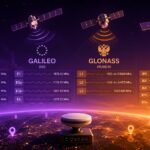
GLONASS (Russia)
GLONASS takes a structurally different approach to spectrum than the other three systems. Older GLONASS satellites use Frequency Division Multiple Access (FDMA), meaning each satellite transmits on a slightly different frequency within a band rather than all satellites sharing one frequency with unique codes, which is how GPS, Galileo, and BeiDou operate.
G1 (L1): approximately 1,598.0625 to 1,604.25 MHz, spread across multiple channels assigned to individual satellites.
G2 (L2): approximately 1,242.9375 to 1,248.625 MHz, again spread across channel-specific frequencies.
G3 (L3): 1,202.025 MHz is a newer GLONASS civil signal, introduced on more recent satellites, that uses Code Division Multiple Access (CDMA) instead of FDMA, aligning GLONASS more closely with the signal structure used by GPS, Galileo, and BeiDou and easing the path toward combined-constellation receiver chipsets.
The FDMA legacy is the main reason GLONASS-compatible chipsets historically required more complex front-end hardware than GPS-only receivers, since the receiver has to tune across a range of frequencies rather than processing a single fixed carrier.
Galileo (European Union)
Galileo was designed from the outset with interoperability in mind, and its frequency plan reflects that directly.
E1: 1,575.42 MHz sits at exactly the same frequency as GPS L1, a deliberate choice that allows a single receiver front end to capture both signals simultaneously with minimal additional hardware.
E5a: 1,176.45 MHz likewise matches GPS L5 exactly, again by design.
E5b: 1,207.14 MHz is unique to Galileo and GLONASS-adjacent systems, sitting between the GPS L2 and L5 bands, and is often combined with E5a in processing to form a wideband E5 signal with especially strong multipath resistance.
E6: 1,278.75 MHz carries the encrypted Public Regulated Service (PRS) used for government and security applications, along with a commercial high-accuracy service, and has no GPS equivalent at the same frequency.
This deliberate frequency alignment with GPS is the single biggest reason modern smartphones can track GPS and Galileo satellites together using essentially the same radio front end, materially improving fix speed and accuracy in dense urban canyons where satellite visibility is limited.
BeiDou (China)
BeiDou’s frequency plan evolved across multiple generations of satellites and now spans several bands.
B1I: 1,561.098 MHz carries the original BeiDou civil signal used since the system’s earlier regional phase.
B1C: 1,575.42 MHz is the newer civil signal, again placed at the same frequency as GPS L1 and Galileo E1 for the same interoperability reasons.
B2a: 1,176.45 MHz matches GPS L5 and Galileo E5a.
B2b: 1,207.14 MHz matches Galileo E5b.
B3I: 1,268.52 MHz is unique to BeiDou and used primarily for the system’s authorized service.
BeiDou’s later-generation satellites essentially mirror Galileo’s approach of co-locating civil signals with GPS frequencies wherever possible, reflecting an industry-wide shift toward frequency commonality across constellations rather than each system claiming separate spectrum.
Side-by-Side Comparison
| Frequency Range | GPS | Galileo | GLONASS | BeiDou |
|---|---|---|---|---|
| ~1,176 MHz | L5 (1,176.45) | E5a (1,176.45) | — | B2a (1,176.45) |
| ~1,202–1,207 MHz | — | E5b (1,207.14) | G3 (1,202.025) | B2b (1,207.14) |
| ~1,227 MHz | L2 (1,227.6) | — | G2 (1,242.9–1,248.6 FDMA) | — |
| ~1,268–1,279 MHz | — | E6 (1,278.75) | — | B3I (1,268.52) |
| ~1,561 MHz | — | — | — | B1I (1,561.098) |
| ~1,575 MHz | L1 (1,575.42) | E1 (1,575.42) | G1 (1,598.1–1,604.25 FDMA) | B1C (1,575.42) |
The clustering around 1,176 MHz and 1,575 MHz is not coincidental. These two points have become the de facto shared frequencies across nearly every modern GNSS constellation, and any GNSS chipset built today is designed around capturing both regions efficiently.
Why This Matters for Receiver Design
A receiver capable of tracking signals from all four constellations across both shared frequency regions is described as multi-constellation, multi-frequency, and represents the current high end of consumer and professional GNSS hardware. This combination delivers three concrete benefits: faster initial position fixes because more satellites are visible at any given moment, better accuracy in obstructed environments like cities and forests because more total satellites compensate for any one constellation being partially blocked, and built-in ionospheric correction because comparing the L1/E1/B1 region against the L5/E5a/B2a region cancels out the frequency-dependent delay without needing ground-based correction signals.
This is also why high-precision applications such as surveying, agriculture, and autonomous vehicles have moved decisively toward multi-frequency, multi-constellation receivers over the past decade, while basic consumer devices still often rely on single-frequency tracking limited mostly to L1/E1/B1C, accepting several meters of positioning error as an acceptable tradeoff for lower hardware cost and power consumption.
Regional Augmentation Systems
Beyond the four global constellations, several regional systems extend coverage and accuracy in specific geographies. Japan’s QZSS broadcasts on the same frequencies as GPS L1, L2, and L5 specifically to supplement GPS visibility over Japan and the Asia-Pacific region. India’s NavIC operates primarily in L5 and S-band (2,492.028 MHz) to provide independent regional coverage over the Indian subcontinent. Both systems illustrate the same underlying trend as Galileo and BeiDou: new entrants increasingly choose to align with existing GPS frequencies rather than claim separate spectrum, since interoperability now outweighs the benefits of frequency independence for nearly every practical application.